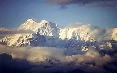
|
Charikot
- Dolakha - Dolkha |
 |
Nepal Tourist Destinations |
|
|
|
| Charikot (Dolakha) |
 |
 |
Charikot
is
located at 2000 m to the north-east of Kathmandu can be reached in 4-5
hours by car. The Arniko Highway, the road to Tibet, descends to the valley
of the Sun Koshi, offering a scenic view of the whole Himalayan range. |
Turning
east by crossing the Sun Koshi river the manainous road climbs up
to 2,600 m providing spectacular views of the mountains of the East and
West before gently descending to charikot, situated on a ledge, 1000 above
the Tama Kosi valley.
Dolakha
is
an old settlement known for its shrine of Dolakha Bhimsen, the patron
deity of businessmen. It is 4 km from Charikot (133
km) on the Lamosangu - Jiri Highway that branches off to the east
from the Arniko Highway at Lamosangu. Dolakha
is
a chance to visit an historic place and enjoy fantastic near- range views
of Mt. Gauri Shankar.
 |
|
The
region is bordered by the Sun Koshi River on the west and the Khimti
Khola River on the eastem edge. It is divided unequally by the River
Tama Koshi, proportionately two thirds to the west of the river and one
third to the east.
To the north east lies the impressive Rolwaling Himal,
to the western edge of which are such peaks as Gauri Shanker and Melungtse.
|
|
Gauri
Shanker is synonymous with the god Shiva andhis consort Parvati.
To
the north-west the mountains slope gently downwards towards the ancient
pass of Kuti that starts above the Tibetan town of Khasa and follows the
waters of the Bhote Koshi from Tibet.
The
river flows past Kodari and Tatopani (Hot Springs) on the Nepalese side
and gradually rushes down into an ever-widening stream of water that becomes
the Sun Kosi.
Khimti Khola drains down from a region of five lakes called Panch Pokhari.They
have a specifc place in legend and go by the names of Mohi (buttermilk),
Jata (hair), Dudh (milk), Bahula (insane) and Bhut (ghost). People believe
that if one bathes in Bahula Pokhari one will become insane, whereas
the Ghost Lake cannot bear the smell of human perspiration and will
pull one inside its murky waters to a certain death if you as much as venture
near it. The Khimti Khola joins the Tama Koshi, as do the Khare Khola and Rolwaling
Khola to the north-east and the Sangawati, Dolti and Charnewati Kholas
to
the west.
It
is a beautiful region in which the riverine valleys open out into massive
volcanic folds. Sub-tropical settlements on the banks of rivers boast banana
trees, guava and an abundance of fish. Above the banks hover the terraced
fields of paddy, make, wheat and millet.
Between
Charikot and Jiri the road descends to 845 metres and to our surprise is
bordered by plantations of sugar-cane. Above these slopes are forests of
dark oak, fir and pine, interspersed with tangles of bracken and fem all
in the embrace of clinging orchids and coloured in the springtime
by the rhododendrons, the national flower of our mountain land.
|
more information
|
 |
|


