| Chronology of earthquakes |
 |
Bhutan Earthquakes |
|
 |
Bhutan Earthquakes |
|
|
 |
|
Chronology of earthquakes in Bhutan
|
 |
 |
|
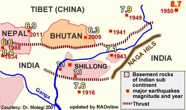
A total of 30 earthquakes have been recorded in Bhutan between the years 1937 to 1998.
Records with the department of geology and mines indicate that a 1941 earthquake, on January 21, was the most powerful, measuring 6.75 on the Richter scale.
|
|
1713 : Richter M 7.0
Located somewhere in Bhutan or in Arunachal Pradesh severely affected Bhutan and parts of Assam.
11 June 1806: M 7.6
In Tibet near Eastern Bhutan. 12 June 1897: R 8 +
Near Rangjoli, Assam (60 Km south of Bhutan) This earthquake is the largest known in the last two centuries in the Indian subcontinent and destroyed Punakha and Lingzhi dzongs; damaged Wangduephodrang, Trongsa, Jakar and Tashichho dzongs.
12 May 1906: M 6.5
Bhutan - China - India border region,
13 Aug. 1910: M 5.7
North of Punakha, Bhutan - India border
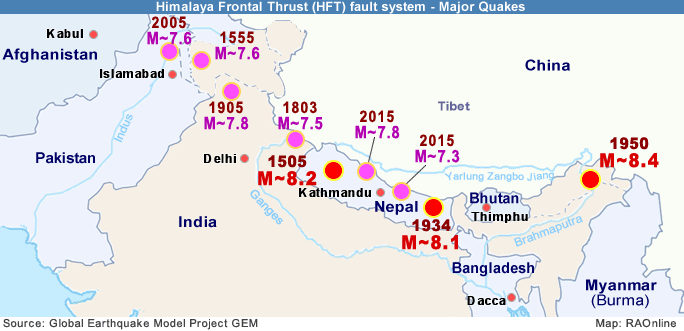
15 Jan. 1934: R 8.0
Bihar-Nepal border
21 Jan. 1941: M 6.7
West of Tashigang, Bhutan- India border
29 July 1947: M 7.3
Arunachal Pradesh - China Border
15 Aug. 1950: M.69
Indo-China Border Region
23 Feb. 1954: M 6.4
Bhutan - China - India border
29 July 1960: M 6.59
Near Tsirang, Bhutan
19 Nov. 1980: M 6.39
Near Sikkim - West Bengal border
20 Aug. 1988: M 6.8
Udaypur Gahri, Nepal,
26 March 2003: M 5.5
Gunitsawa, Paro, Bhutan
11 Feb. 2006: M 5.0
Indian state of Arunachal Pradesh. The earthquake was felt in Trashigang and the neighbouring region.
14 Feb. 2006: M 5.7
In Sikkim with several damages to buildings recorded in Gangtok, Sikkim.
24 Feb. 2006: M 5.8 - 5.5
The two earthquakes in Bhutan, damaged a total of 126 houses in nine gewogs under Trashigang dzongkhag. Trashigang Dzong had numerous new cracks on the wall.
21 Sept. 2009: M 6.3
Hit Mongar with 1,100 houses affected and 12 dead.
18 Sept. 2011: M 6.9
A 6.9 magnitude earthquake with the epicentre located 64km north-west of Gangtok, capital of Sikkim (India),caused widespread damage in parts of India, Nepal, China, and Bhutan.
 |
| This
article was contributed by KUENSEL, Bhutan's National Newspaper, 2009 (updated by RAOnline) |
| Information on Bhutan |
 |
|


