|
Afrika
- Kenia |
|
|
Afrika
- Kenia |
|
|
Kenia - Umweltatlas
|
 |
|
|
Kenia 2009 - Atlas of Our Changing Environment
|
 |
 |
| Kenya's
chances of realizing its 2030 vision will depend increasingly on the way
the country manages its natural or nature-based assets, a new satellite-based
atlas concludes.
Many
of these economic assets are coming under rising pressure: from shrinking
tea-growing areas to disappearing lakes, increasing loss of tree cover
in water catchments and proliferating mosquito breeding grounds, environmental
degradation is taking its toll on Kenya's present and future development
opportunities. |
|
Thus
improved and more creative management is urgently needed to translate the
aspiration, to the realizing of Vision 2030.
These
are among the key conclusions of the new 168-page Atlas produced by the
United Nations Environment Programme (UNEP) at the request of the Government
of Kenya.
Kenya:
Atlas of Our Changing Environment was launched by Kenyan Environment
Minister John Michuki and UN Under-Secretary-General and UNEP Executive
Director Achim Steiner.
It
is the first-ever publication of its kind to document environmental change
in an individual country, through the use of dozens of satellite images
spanning the last three decades.
The
request for the Atlas, funded by Norway and supported by the United States
Geological Survey, follows the launch last June in Johannesburg of Africa:
Atlas of Our Changing Environment at a meeting of the African Ministerial
Conference on the Environment.
Mr
Steiner said: "The Kenya Atlas shows both the diversity and the fragility
of the country's natural assets which are at the heart of the nation's
socio-economic development. It highlights some success stories of environmental
management around the country, but it also puts the spotlight on major
environmental challenges including deforestation, soil erosion and coastal
degradation."
"The
Atlas makes a strong case that investments in green infrastructure within
a Green Economy can bring it closer to achieving the Millennium Development
Goals. The Atlas is for the government and for all Kenyans who want to
see transformational change and a path out of poverty to prosperity by
sustainably realizing this country's true development potential," he added.
|
Key
findings of the Kenya Atlas
|
|
Some
of the key findings of the Kenya Atlas include:
-
The nation has increased the proportion of land area protected for biological
diversity from 12.1 percent in 1990 to 12.7 percent (about 75 238 sq. km)
in 2007.
-
The land available per person in Kenya has dropped from 7.2 hectares per
person in 1960 to just 1.7 ha per person in 2005 due to the rapid population
growth of the last few decades. There are now 38 million inhabitants in
Kenya, up from just eight million in 1960. The population is expected to
keep rising, and land available per person is projected to drop to 0.3
ha per person by 2050.
-
Five water towers - Mau Forest Complex, Aberdares Range, Mt. Elgon, Cherangani
Hills and Kakamega Forest - are critical as water catchments, vital for
tourism, and hence towards achieving Kenya's vision 2030.
-
The rivers flowing from the Mau Complex are the lifeline for major tourism
destinations including the Maasai Mara Game Reserve and Lake Nakuru National
Park. In 2007, revenues from entry fees alone amounted to Ksh. 650 million
(US$ 8.2 million at today's exchange rate) and Ksh. 513 million (US$ 6.3
million at today's exchange rate) for the Maasai Mara and Lake Nakuru respectively.
-
A temperature rise of just 2 degrees Celsius would make large areas of
Kenya unsuitable for growing tea, which accounts for 22 percent of the
country's total export earnings. Some 400,000 smallholder farmers grow
60 percent of Kenyan tea.
-
Rapid population growth coupled with conversion of land cover within Lake
Olbollosat's catchment is posing a huge threat to the lake which has periodically
dried up and then come back to life in the past. There is concern that
the increasing number of pressures may mean that if it dries up again,
it could be the end of Lake Olbollosat.
-
The value of soil lost due to erosion in Kenya each year is three to four
times as high as the annual income from tourism. In 2007, earnings from
tourism totaled 65.4 billion Kenyan Shillings (or more than US$ 824 million
at today's exchange rate).
-
Forest loss increases key health risks such as malaria. Research in the
western district of Kisii shows that old natural habitats with a greater
diversity of mosquito predators - such as dragonflies and beetles - have
a lower density of mosquitoes. Intact forests also have less breeding sites
for mosquitoes. Thus conserving forests has multiple economic benefits
from soil stabilization, improved water supplies, more reliable hydro-power
and tourism to health ones including reducing the risk of malaria epidemics.
-
The Cherangani Hills have seen less forest loss than the other "water tower"
forests in recent years and significant areas of indigenous forest remain.
Monitoring and careful management are needed to preserve these valuable
assets.
|
From
Maasai Mara to Lake Turkana - Kenyan ecosystems under pressure
|
|
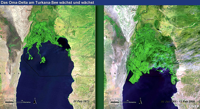
The
Atlas's before-and-after satellite images in this Atlas vividly document
the environmental change in 30 locations across Kenya since 1973 including:
-
The Mau Forest Complex, a key water catchment is being deforested at an
alarming rate due to charcoal production, logging, encroachment and settlements.
One quarter of the Mau forest - some 100,000 hectares - has been destroyed
since 2000.
-
Large scale, uncontrolled, irregular, or illegal human activities like
charcoal production, logging, settlements, and crop cultivation, among
others, caused devastation within the Aberdares range. The construction
of a fence around the Aberdare Range has reduced/stopped uncontrolled,
irregular, or illegal human activities within the forest, as well as human
wildlife conflicts.
-
The Atlas underlines the kinds of economic and environmental choices facing
policy-makers. For example it notes that the vast ecotourism potential
of the Aberdare National Park remains largely untapped, with just 50,000
visitors per year on average.
-
Large mechanized wheat farms in the area surrounding the Maasai Mara have
expanded by 1,000 percent between 1975 and 1995, most of them on the Loita
Plains, significantly reducing the available natural grasslands in this
important habitat for wildebeest - a key economic species in terms of tourism.
-
Between 1973 and 2006, almost half of the natural vegetation cover around
Lake Nakuru, another big tourism attraction not least for its pink flamingoes,
was lost. The satellite pictures show a clear degradation of forest cover
west of the lake, partly due to the excision of 350 square kilometers of
forest in 2001.
-
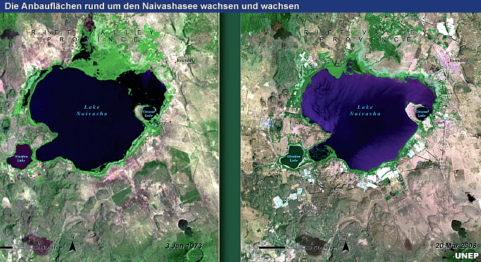
Lakes across the country are under intensified pressure, with Lake Naivasha
struggling to cope with the expansion of settlements and flower farms in
the towns of Naivasha and Karagita; Lake Turkana losing water through a
combination of decreased rainfall, increased upstream diversion and increased
evaporation due to higher temperatures.
-
Prosopis - a terrestrial shrub - has blocked pathways, altered river courses,
taken over farmlands, and suppressed other fodder species in the areas
around Lake Baringo since the 1980s.
-
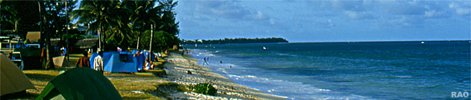
Some estimates suggest that about half of the mangroves on Kenya's coast
have been lost over the past 50 years due to the overexploitation of wood
products and conversion to salt-panning, agriculture and other uses.
Towards
achieving the Millennium Development Goals and Vision 2030
According
to the data presented in the Atlas, Kenya has made some important strides
towards achieving some of the Millennium Development Goals (MDGs) - with
notable headway in the fight against poverty, the provision of universal
education and the fight against HIV/AIDS, malaria and other diseases.
Yet
challenges remain for Kenya on the road to achieving environmental sustainability,
notably limited government capacity for environmental management and insufficient
institutional and legal frameworks for enforcement and coordination.
The
Atlas notes that deforestation, land degradation and water pollution are
some of the challenges Kenya needs to address to achieve MDG7, 'Ensure
Environmental Sustainability'.
One
key finding of the Atlas is that achieving environmental sustainability
is fundamental to achieving all the MDGs. Environmental resources and conditions
have a significant impact on many aspects of poverty and development.
"One
of the most powerful ways to help achieve the first MDG - eradicate extreme
poverty and hunger - is to ensure that environmental quality and quantity
is maintained in the long term," the authors say.
For
instance, poor people often depend on natural resources and ecosystems
for income; time spent collecting water and fuelwood by children can reduce
the time at school; and environment-related diseases such as diarrhoea,
acute respiratory infection, leukemia and childhood cancer are primary
causes of child mortality.
"Vision
2030, with its ambitious development blueprint, is a key opportunity for
the Kenyan Government to address environmental challenges as a key element
underpinning the country's sustainability and development," concludes the
Atlas.
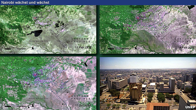
Kenya: Atlas of Our Changing Environment features numerous satellite images taken
around Kenya, along with 65 maps, 26 graphs and 229 ground photographs
illustrating the environmental issues faced by the country.
The
Atlas provides compelling visual evidence of the changes taking place in
30 locations across the country's critical ecosystems due to pressures
from human activities.
The
before-and-after display of satellite images spanning three decades highlights
forest loss, wetland drainage, shrinking lakes and coastal degradation,
as well as examples of good management and successful environmental strategies.
The
Atlas analyzes the linkages between the country's major socio-economic
activities and its key natural resources -illustrating, for example, the
link between agricultural productivity and forests, which regulate the
micro-climates that make farming possible.
The
Kenya Atlas follows on from UNEP's Africa: Atlas of Our Changing Environment,
published in June 2008, which gave an overview of environmental change
across the continent.
All
the materials in the Atlas are non-copyrighted and available for free use.
Individual
satellite images, maps, graphs and photographs, can be downloaded from
http://na.unep.net
The
Atlas can also be purchased at www.earthprint.com
The
digital version of the Atlas will also be released on Google Earth and
other websites.
|
| Source:
United Nations Environment Programme (UNEP), 2009 |
|
Kenya- Atlas of Our Changing Environment
|
|
nach
oben
|
Video
|
|
nach
oben
|
Kenia - Umwelt im Wandel
|
|
nach
oben
| Weitere Informationen |
|
| RAOnline: Weitere Informationen über Länder |
|
Links
|
|
 |
|
Externe
Links |

|
|
Atlas
of Our Changing Environment
|
|
 |
|