|
Nepal's
Nature - Climate Change
|
 |
Nepal Himalayas Glaciers |
|
 |
Nepal Information |
|
|
 |
|
Fast
Melting Glaciers Could Raise the Likelihood of Floods and Water Shortages
|

|
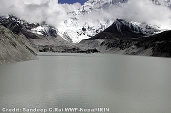 |
Global warming created this lake out of glacier
| The
rapid shrinking of Himalayan glaciers, which has accelerated at a considerable
rate over the past decade, could have catastrophic consequences for communities
living downstream and the millions who rely on glacial melt water, a new
report says. The report, with detailed case studies on the impact of warming
temperatures on glaciers and glacial lakes in two glacial hot-spot areas
in the Himalayan region, warns of the increasing likelihood of glacial
lake outburst floods (GLOFs) - when rising waters from glacial melt breach
the dam holding back a glacial lake - and calls for early warning and mitigation
measures to avert disaster. |
|
The
extended Himalayan mountain range feeds nine perennial river systems in
the region which constitute a lifeline for nearly 1.3 billion people downstream.
Nearly 15,000 glaciers and 9,000 glacial lakes have been identified across
five countries in the region - Bhutan, Nepal, Pakistan and selected basins
of India and China. Of these, some 200 lakes have been identified as potentially
dangerous.
Observations
of individual glaciers indicate that, in some cases, rates of retreat have
doubled since the early 1970s, though they vary from basin to basin. The
Dudh Koshi is the largest sub-basin and most densely glaciated region in
Nepal and contains 12 of the 20 potentially dangerous glacial lakes identified
in the country. The glaciers in this basin are retreating at an average
of 10 to 60 m annually; the Imja glacier by as much as 74 m a year. Melting
glaciers are also leading to some of the fastest-growing glacial lakes
in the region; the lakes form in the gap left between the retreating glacier
terminus and the end moraine.
In
Bhutan, the Luggye Glacier retreated by 160 m between 1988 and 1993 resulting
in rapid growth of the lake Luggye Tso. The Raphstreng Glacier retreated
35 m per year on average between 1984 and 1988; the retreat rate almost
doubled to 60 m per year between 1988 and 1993.
Glacial
lake outburst floods can have varying degrees of socioeconomic impact.
Their impact can be quite extensive since they can destroy villages, agricultural
land, roads, bridges, hydropower plants, and trekking trails, as well as
causing loss of life. The Tibetan Zhangzhangbo GLOF in 1981 caused extensive
infrastructural damage and nearly US$3 million in losses. The Dig Tsho
GLOF in Nepal in 1985 destroyed a power plant with a loss of US$1.3 million,
destroyed homes and land, and caused considerable loss of life. The Luggye
Tso GLOF in Bhutan in 1994 damaged the sacred Dzong and cultivated land,
and also caused loss of life.
|
Fear
of flooding
|

|
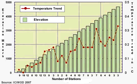
The
Hindu Kush-Himalaya glaciers are also an important source of freshwater
for hundreds of millions of people living downstream. Glacial retreat is
also causing long term loss of natural fresh water storage.
 |
| "The
significance of these glaciers and glacial lakes to downstream communities
is of particular importance. Changes in glacier ice or snowmelt affects
water yield to downstream regions heightening the risk of water shortages,
impacts irrigation water for crops, and may disrupt industry and power
generation," said Dr. Andreas Schild, Director General of the International
Centre for Integrated Mountain Development. |
|
"We
have to continue monitoring glaciers and glacial lakes to ensure sound
management of these valuable water resources. In addition, the use of early
warning systems like satellite-based techniques, dam breach, and hydrodynamic
modelling are important for implementing mitigation measures to reduce
risks to vulnerable mountain populations," said Surendra Shrestha, Regional
Director of the UNEP Regional Office for Asia and the Pacific.
The
report, The Impact of Climate Change on Himalayan Glaciers and Glacial
Lakes, was produced by the International Centre for Integrated Mountain
Development (ICIMOD) with the United Nations Environment Programme (UNEP)
and launched during the World Environment Day regional celebrations held
in Kathmandu, Nepal on 5 June 2007.
World
Environment Day, commemorated each year on 5 June 2007, is one of the principal
vehicles through which the United Nations stimulates worldwide awareness
of the environment and enhances political attention and action. The World
Environment Day slogan for 2007 is "Melting Ice - a Hot Topic?" In support
of International Polar Year, the WED theme selected for 2007 focuses on
the effects that climate change is having on polar ecosystems and communities,
and the ensuing consequences around the world.
top
|
The
Melting Himalayas
|

|
This
policy summary looks at reported and possible, future consequences of climate
change in the greater Himalayan region. The main emphasis is on responses
in high mountain cryogenic phenomena such as glaciers, permafrost, and
avalanches; the implications for water supply, ecosystems, and hazards;
and how these threaten regional populations. The assessment points to a
serious need to improve relevant knowledge in the region concerning key
policy areas and strategies to improve the adaptive capacities of communities
at risk.
 |
| The
greater Himalayan region is taken to include the inner and south Asian
mountains and high plateaux. It contains the most extensive and rugged
high altitude areas on Earth, and the largest areas covered by glaciers
and permafrost outside high latitudes. The ecosystems and human cultures
in this region are exceptionally diverse. Global climate change is predicted
to lead to major shifts in the strength and timing of the main climate
systems affecting the region: the Asian monsoon, inner Asian high pressure
systems, and Westerlies. Moreover, climate change is expected to intensify
in mountain areas, especially high relief, sub-tropical areas. Already
of major concern is the rapid reduction of glaciers in much of the region. |
 Download Document Download Document |

|
This,
in itself, is signifi cant and has implications for regional water resources,
as well as being an indicator of the scale of climate change. Some major
hazards, from debris flows to glacial lake outburst floods (GLOFs), are
becoming more frequent and severe (Beniston 2003). In fact, all aspects
of the Himalayan cryosphere are affected by climate change. They include
vast areas of permafrost and areas subject to snow avalanches or freeze-thaw
and are affected by the changing balance between snow and rainfall. Complexities
arise, especially from interactions among different cold climate elements.
The
most rapid and varied interactions occur through the vertical 'cascade'
of moisture and sediment between different topoclimates. Large and rapid
downslope, down-glacier, or downstream cascades also exaggerate the scale
and diffi culty of predicting hazards such as debris flows and flash floods.
The varied ability of mountain species to respond as temperature warms,
glaciers retreat, and weather extremes become more common threatens extinction
for some and is a threat to biodiversity in general.
An
important theme is the enormous diversity within the region in climates
and topoclimates, hydrology and ecology, and, above all, in human cultures
and the ways in which their activities are complexly interwoven with elements
of the cryosphere and alpine ecosystem. The complex regional differentiation
magnifi es the signifi cance of two major problems: the widespread absence
of basic scientific investigations into cryogenic processes and limited
knowledge of the human cultures and ongoing developments in them. This
leads to the theme of 'uncertainty on a Himalayan scale', referring more
to problems of limited knowledge than inherent physical and social uncertainties.
The
impacts of climate change are not evenly distributed in intensity within
the region, nor among different communities and sectors of society. However,
the poorer, more marginalised, people of the high mountains are likely
to suffer the earliest and the most. Given the evidence that many risks
already threaten women disproportionately; and also the elderly, disabled,
and indigenous groups, especially their poorer members; identifying changes
in the cryosphere and alpine ecosystem most likely to affect them is of
utmost importance. In addition, there are broader regional questions of
which the more severe highland-to-lowland dangers relate to rapid melting
events, floods caused by natural dam bursts, increased sedimentation, and
droughts caused by reduced or changed flow patterns.
Of
course, mountain people have lived with and survived great hazards for
thousands of years, but current rates of climate change are among the most
rapid known and they are superimposed on severe and, equally, uncertain
socioeconomic pressures. A range of issues and policy areas are identifi
ed, from the regional to local community levels, through which these problems
might be addressed. They involve land use, water management, disaster management,
energy consumption, and human health. It is argued that community-led adaptive
strategies and capacities, as well as substantial efforts to reverse the
human drivers of climate change, are needed. An important practical and
ethical requirement is for all levels of government, research, non-government
organisations, and professions to engage with mountain communities in combined
efforts to increase their adaptive capacities to climate change.
top
|
Flash
Floods in the Himalayas: Summary
|

|
 |
| The
Himalayas are one of the youngest mountain ranges on earth and represent
a high energy environment very much prone to natural disasters. High relief,
steep slopes, complex geological structures with active tectonic processes
and continued seismic activities, and a climate characterised by great
seasonality in rainfall, all combine to make natural disasters, especially
water-induced hazards, common phenomena.
Flash
floods are among the more devastating types of hazard as they occur rapidly
with little lead time for warning, and transport tremendous amounts of
water and debris at high velocity. Flash floods affect thousands of people
in the Himalayan region every year - their lives, homes, and livelihoods
- along with expensive infrastructure. |
 Download Document Download Document |
Intense
rainfall
Intense
rainfall is the most common cause of flash floods in the Himalayan region.
These events may last from several minutes to several days. Such events
may happen anywhere but are more common to mountain catchments. The main
meteorological phenomenon causing intense rainfalls in the region are cloudbursts,
stationarity of monsoon trough and monsoon depressions.
Landslide
dam outburst
Debris
from a landslide can temporarily block the flow of a river creating a reservoir
in the upstream reach. The landslide dam can breach due to overtopping
and cause huge floods known as landslide dam outburst floods (LDOF).
Glacial
lake outburst
The
glaciers in the Himalayas are mostly retreating, and as they retreat lakes
can form from melt water held in by the now exposed terminal moraine acting
as a dam. If the dam breaks the water can be released suddenly resulting
in a glacial lake outburst flood.
Impact
of climate change
Intense
rainfall floods and landslide dam outburst floods are directly related
to the hydrometeorological conditions and likely to be affected by climate
change. Climate models project an increase in monsoon precipitation in
the region. Similarly the frequency and magnitude of extreme rainfall events
are also anticipated to. GLOFs are related to glacial retreat which in
turn is mainly due to climatic warming. It is therefore very likely that
flash floods due to intense rainfall, landslide dam outbursts, and glacial
lake outbursts will increase in the future.
ICIMOD
initiatives
While
the region is highly exposed to flash flood hazards, due to poor socioeconomic
condition the vulnerability is also high. In general the capacity to manage
the risk of flash floods is low. ICIMOD has undertaken several initiatives
targeted towards mitigation of the impact of flash floods including development
of an inventory of glaciers and glacial lakes for a part of the Hindu Kush-Himalayan
region; an international workshop on flash floods in Lhasa, PR China; capacity
building for flash flood risk management; and satellite rainfall estimation.
ICIMOD will continue to work in flash flood management in the region particularly
in raising awareness towards flash floods, increasing capacity to manage
the risk, and linking flash floods risk management with climate change
adaptation.
top
|
ICIMOD
- International Centre for Integrated Mountain Development
|

|
The
International Centre for Integrated Mountain Development (ICIMOD) is an
independent 'Mountain Learning and Knowledge Centre' serving the eight
countries of the Hindu Kush- Himalayas - Afghanistan , Bangladesh , Bhutan
, China , India , Myanmar , Nepal , and Pakistan - and the global mountain
community. Founded in 1983, ICIMOD is based in Kathmandu, Nepal, and brings
together a partnership of regional member countries, partner institutions,
and donors with a commitment for development action to secure a better
future for the people and environment of the extended Himalayan region.
ICIMOD's activities are supported by its core programme donors: the governments
of Austria, Denmark, Germany, Netherlands, Norway, Switzerland, and its
regional member countries, along with over thirty project co-financing
donors. The primary objective of the Centre is to promote the development
of an economically and environmentally sound mountain ecosystem and to
improve the living standards of mountain populations.
top
|
Documents
|

|
| Regional
Challenges and Local Impacts of Climate Change on Mountain Ecosystems and
Livelihoods |
 |
| 1.1
MB PDF-File |
 |
| 244
KB PDF-File |
 |
|
 |
 |
| 3.9
MB PDF-File |
 |
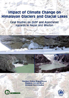
Case Studies
on GLOF and Associated Hazards in Nepal and Bhutan (2007)
This
study, prepared in close cooperation with and supported by the United Nations
Environment Programme Regional Office for Asia and the Pacific, investigates
the impact of climate change on glaciers and glacial lakes in two major
glacial hotspots in the Himalayas: the Dudh Koshi sub-basin in the Khumbu-Everest
region in Nepal, and the Pho Chu sub-basin in Bhutan. |
|
 |
|
Snow, Ice, Glaciers, Glacial Lakes and Floods - Reports
|

|
|
Himalayas
|
 |
Snow, Ice, Glacier, Glacial Lakes and Floods Reports |

|
top
|
more information
|
 |
|
Links
|

|
 |
 |
External
link |
|


