 |
Nepal Trekkings |
|
|
 |
| New Trekking Routes in Nepal |
 |
 |
From Rara National Park to Khaptad National Park |
TAAN explores new trail to Khaptad
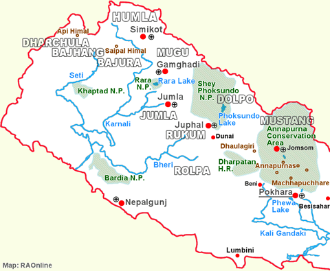
TAAN has completed exploration of a new trekking route that links Rara National Park in Mugu to Khaptad National Park.
 |
| A seven-member team led by Rana Bahadur Khadka, 1st vice president of Trekking Agencies' Association of Nepal (TAAN), had embarked on an exploration trip to mid and far western region on June 7, 2013. The team comprised of photographer, cartographer, report writer, TV crew and local media persons.
The trail begins from Talcha airport in Mugu and passes through Sirkot, Sukhadhik and Kolti of Bajura.
It enters Khaptad National Park from Kolti and passes through Tamail, Budhakholi, Baaisdhara, Surmasarobar, Dhulichaur and Chainpur before ending at Dhangadhi. |
|
The team held interaction with local stakeholders at Tamail and Chainpur.
"Tribeni and ashram of Khaptad Baba are the major attractions in Khaptad National Park.
By exploring and promoting this trail, we hope to encourage tourists visiting Rara National Park to visit Khaptad National Park," said Khadka. "We will prepare documentary, detailed itinerary and map to promote the trail."
The trail offers magnificent views of mountain peaks like Api and Saipal.
This is the first time that TAAN has explored new trekking trails in the far-western region. TAAN completed exploration of new trekking trail in Humla and Mugu in April 2013.
Last year, it explored Lumba-Sumba area in the Kanchanjunga region, Lower Manaslu in the Manaslu region, Ruby Valley in the Ganesh Himal area and Dolpo in the mid-western region.
 |
From Sulichaur (Rolpa) to Jaljala (Rolpa) |
TAAN completes exploration of Jaljala trail
A joint team of Trekking Agencies' Association of Nepal (TAAN) and Jaljala Tourism Development Committee, Rolpa has completed exploration of Jaljala area in Rolpa district.
 |
| The Jaljala region is rich in natural beauty. The region is home to different species of flora and fauna including the endangered Red Panda.
The team has explored and recommended 10-day trek that starts from Sulichaur of Rolpa. Regular bus service to Sulichaur is available from Kathmandu.
The trek then passes through Fuliban, Uwabesi, Kotal Baraha, Pusbang, Righa, Ajambari Commune, Thabang and Bhedikharka before reaching Jaljala. There are three temples of Baraha and a cave in Jaljala. |
|
The trail also offers magnificent views of Sisne Himal, Gurja Himal, Putha Himal and Dhaulagiri, among others.
From Jaljala, the trail progresses through Dharampani, Majhbang and Jelbang before concluding at Sulichaur.
Prakash Khadka of TAAN, who led the exploration trek, said culture and lifestyle of Magar and wildlife are the major attractions of the trek. "Also Jaljala can be developed as a trekking hub of the region, as one can joint Guerrilla Trek, trek to Dhorpatan and enter the Dolpo region via Jaljala," Khadka added. "The region also holds great prospect for war tourism as the decade-long people's war originated in Rolpa."
The team also held interactions at Sulichaur, Thabang, Majhbang and Jelbang to discuss tourism prospects that the region offers. Local leaders of different political parties and tourism entrepreneurs among others participated in the interaction.
TAAN is preparing a documentary, detailed itinerary and map to promote the region
| Source: Trekking Agencies' Association of Nepal (TAAN), June 2013 |
 |
From Sulichaur (Rolpa) to Jaljala (Rolpa) |
TAAN has explored New trailin Round Dhaulagiri Trek
An alternative trekking trail for the Beni-Darbang section of Round Dhaulagiri trekking route has been identified.
The new trail was explored as the existing Beni-Singa-Tatopani-Babiyachaur-Darbang trail became of new use due to construction of motor roads.
The new trail starts from Beni and progresses through Pachhai, Dholthan, Jagannath, Purnagaun and Darbang.
Local Development Officer of Myagdi Bishnu Prasad Sharma said the new trail was identified with the funding of District Development Committee, Myagdi. He said the survey team has proposed for a budget of Rs 10 million to develop necessary infrastructures along the new trail.
The new trail can be completed in two days. It meets the Round Dhaulagiri Trekking Route at Bim Village Development COmmittee (VDC).
The new trail passes through important historical and religious sites like Dholthan and Jangannath, and viewpoints like Todke.
The DDC Myagdi took the initiative to explore new trail after trekkers started moving to other trekking areas in the country due to movement of vehicles as well as pollution on the existing Beni-Darbang section.
Meanwhile, the DDC Myagdi has set aside Rs 500,000 to develop infrastructures on Todke-Malika section of the new trail.
| Source: Trekking Agencies' Association of Nepal (TAAN), March 2014 |
top
|
RAOnline Nepal
|
 |
 |
| Mount
Everest (8,848 m) and Lhotse (8,516 m) |
top
|
Links
|

|
 |
 |
External
links |
|


