 |
Nepal Information |
|
 |
Nepal Information |
|
|
 |
 |
 |

|
 |
 |
 |
| Name: |
Federal
Democratic Republic of Nepal |
| Climate: |
monsoon
climate, partly influenced by altitude; temperate in winter (0-20°C),
high precipitation and humidity in summer (25-32°C)
Nepal
has a wide range of climatic conditions from tropical forest to snow-capped
mountains and glaciers. The main rainy season is between late June to September
with hot temperatures. The remainder of the year has warm and settled weather.
Rainfall decreases from east to west. |
| Location: |
Nepal
is situated between latitudes 26°N and 31°N and longitudes 80°E
and
88°E along the southern slopes of the central Himalayas |
| Area: |
147,181
km2, 141,181 square km of plains (1 km = 0.62 miles)
Himalayan
foothills and the Himalayan range. Mount Everest and seven more of the
world's
top 10 highest mountains line Nepal's northern border with the Tibetan
autonomous
region of China. Landlocked Nepal is bordered to the west, south and east
by India.
|
| Capital: |
Kathmandu (population of Kathmandu Metroplis: approx 2.5 million by 2015) |
| Constitution |
September 20, 2015
Nepal adopts new constitution
Nepal's President Ram Baran Yadav announced the adoption of theconstitution during a Constituent Assembly meeting. The new constitutionis the first to be drafted by elected representatives. |
| Population: |
approx.
27.8 million (2013), population growth: 2.4% , approx. 52.4 million (2050)
October,
2005: Nepal's population has reached 27.1 million, according to the United
Nations Population Fund (UNFPA). |
| Language: |
Nepali
(official language) and about 50 regional languages
The
official language is Nepali in the Devanagari script. It is related to
Hindi, but it is only spoken by just over half the population. There are
numerous other languages, including Awadhi, Bantawa, Bengali, Bhojpuri,
Chepang, Gurung, Hindi, Kham, Limbu, Magar, Maithili, Newari, Rajbangsi,
Santali, Sherpa, Sunwar, Tamang, Tharu and Tibetan. Hindi and English are
also used in official and commercial circles.
|
| Ethnic
group: |
Nepali
(official language) and about 50 regional languages
A
mixture of Indo-Aryan peoples, who originally migrated from India, and
a range of Mongol tribes, including the Gurungs, Magars, Rai and Limbu,
who speak Tibeto-Burman languages. The Kathmandu valley is the home of
the Newar community, while small communities of indigenous peoples and
Muslim immigrants are found in the Terai.
|
| Religion: |
80%
Hindu, 15% Buddhist, 2.7% Muslim, 2% Christian
Nepal
is the world's only officially Hindu nation, with 86.2 percent Hindu, 7.8
percent Buddhist, 3.8 percent Muslim and 0.2 percent Christian.
|
| National
Day: |
New
day to declare.
|
| Independency: |
has
always been independent, founded as a Kingdom in 1768 |
 |
|
 |

|
 |
| System
of government: |
May
28, 2008
Republic: Nepal has become the world's newest federal democratic republic,
ending 240 years of
monarchy.
|
| Parliament: |
consists
of two chambers:
-
the House of Representatives ("Pratinidhi Sabha"): 205 members, directly
elected for 5 years ; last elections May 1999,
-
the National Assembly ("Rastriya Sabha"): 60 members, of which 10 are nominated
by the King, 35 are elected by the House of Representatives and 15 by an
electoral college of the 5 Development regions; the legislative period
is 6 years (one third of the members are newly elected/nominated every
2 years);
January
11, 2007: Interim Paliament
Top
leaders of the four major political parties reached an agreement to share
the remaining 48 seats in the interim legislature-parliament among the
seven-party alliance and the CPN-Maoist. According to the understanding
reached during a meeting held at the Prime Minister's official residence
at Baluwatar, the Nepali Congress, CPN-UML and CPN-Maoist will get 10 seats
each, Nepali Congress (Democratic) six, while Nepal Sadbhavana Party (Anandi
Devi), Nepal Workers' and Peasants' Party, Janamorcha Nepal and United
Left Front will get three seats each out of the 48 seats, initially allocated
for civil society.
11
April 2008: Constituent Assembly Election 2008
Nepal
's Constituent Assembly comprises 601 seats. 240 seats are chosen on a
first-past -the-post system.
There
are also 335 seats distributed by proportional representation. A further
26 seats will be nominated by the government.
|
| Government: |
elected
government (2015: multiparty government) |
| Churches,
Mosques: |
several
Catholic, Protestant and Muslim communities |
| Administrative
structure: |
5
Development regions, 75 districts, 61 towns, about 4,000 villages; decentralized
administration; village, town and district councils
New constitution: federalism and provinces
On 20 September 2015 Nepal has adopted a new constitution. The four major parties in the Special Committee of the Constituent Assembly’s Constitutional Political Dialogue and Consensus Committee have agreed in carving outsix federal provinces in Nepal (six-Pradesh model with the boundaries of new federal states).
|
| Principal
media: |
Radio
Nepal, Nepal Television Corporation, RSS (news agency), Rising
Nepal
(English-language newspaper), all four state-owned; private
newspapers:
Gorkhapatra (Nepali), Kathmandu Post (English), Kantipur
(Nepali)
|
| Currency: |
1
Nepalese rupee (NPR) = 100 paisas
|
 |
|
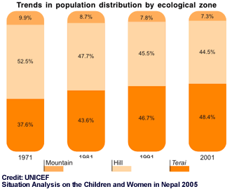
Population
Distribution
|
 |
| More
information and pictures |
 |
|


