| Bhutan's
glaciers and glacial lakes |
 |
Bhutan Glaciers - Glacial Lakes |
|
|
Bhutan Glaciers - Glacial Lakes |
|
|
 |
|
Global
warming guarantees GLOF |
|
Glacial
Lake Outburst Floods (GLOF) |
 |
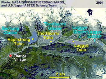 |
Bhutan's glacial lakes
| If
UNDP's projection of a possible outburst of Thorthormi (Thortomi) glacier-lake
in Lunana by 2010 comes to pass, the destruction downstream may be catastrophic.
A team from the department of geology and mines, which joined experts in
the field from Austria, found that Thorthormi (Thortomi) and Raphstreng
lakespose a serious and immediate threat of glacial lakes outburst
floods (GLOF) to life and infrastructure in downstream communities of the
Punakha-Wangdue and Choskhor valleys. |
|
A UNDP situation analysis on vulnerabilities from GLOF in the two valleys
states that about 10 percent of the country's population lives in these
two valleys.
The
report points out that, along the Punatsangchu, the country's longest river,
were emerging townships, important historical structures, major hydropower
projects, farmland and public infrastructural projects. Choskhor valley
in Bumthang was emerging as an important urban, tourist and economic hub.
Geology
and mines officials said that it was impossible to make any predictions
as to how long they have to avert nature's wrath. "They pose no immediate
danger," said the director of geology and mines, Dorji Wangda, adding that,
at the same time, they could not procrastinate mitigation work.
A
geologist, Karma Toeb, who visits the glacial sites every year, said that
each time he saw new and disturbing developments.
While
all the three glacier lakes, Thorthormi
(Thortomi), Raphstreng and Luggye showed signs of bursting individually any time in future, geologists feared
the worst case scenario, where two of the bigger lakes could merge and
flow down as one giant GLOF.
Karma
Toeb said that the Thorthormi (Thortomi) lake adjoining Raphstreng
lake was slightly elevated and separated by just a 75-metre thick (at
the top) moraine dam, which is a mass of earth and rock debris carried
and left at the edges by melting glaciers.
The Thorthormi
(Thortomi) glacier, Karma Toeb said, was solid ice in the 50s. "Glaciers
are melting every year and several small ponds have formed, which are spreading
and joining," he said. "The water from this lake is leaking into Raphstreng."
Recent
studies suggest rates of glacial retreat in the Himalayas as high as 30
to 60 metres a decade.
The
geology and mines director said that they wondered how long the moraine
dams would endure until gradually giving into pressure from the meltingThorthormi
(Thortomi) glaciers. "These moraine dams are cemented by the core ice,
which is melting from global warming," said Dorji Wangda. "The dams will
fail if global warming keeps increasing."
Should
the two lakes join together, geology and mines officials said that it would
burst open to unleash some 53 million cubic metres of floodwater.
During
the 1994 flood in Punakha, the 140-metre deep Luggye tsho burst open and
let out 18 million cubic metres of flood water, which damaged more than
1,700 acres of agriculture and pasture land, washed away five mills, 16
yaks and several houses, six tonnes of food grains, government infrastructure
and killed 22 people.
Geologists
said that rocks and material, occasionally dropping into the narrow gorge,
which was the outlet created by the Luggye tsho when it burst in 1994,
was blocking the thin passageway. This, they fear would allow water volume
to rise until another flood hit the valley down stream.
To
mitigate the threat from Thorthormi (Thortomi) lake, geology and
mines officials will have to dig a channel at the outlet so as to reduce
the water volume in the lake by five metres. "Whenever the water level
rises, it'll flow out through the channel," said karma Toeb. "That won't
allow hydrostatic pressures to build up in the lake," added Dorji Wangda.
The
UNDP sanctioned a total budget outlay of US$ 7.8 million on April 8, for
the mitigation work. Geology and mines officials said that the first phase,
which begins this year, would be used to prepare logistics, stocking up
food and carrying excavating materials and equipment to the glacial site.
"We
can't use explosives, so everything has to be done manually," said Karma
Toeb. The real work of excavation, which is expected to begin in the following
three years after the first phase, would require about 300 workers.
According
to UNDP officials, the project will look into building capacity for disaster
risk management at the national, regional and local levels to address the
need to incorporate climate change into ongoing disaster risk management
decision-making and practices.
It
will also work towards reducing the risk of GLOF from Thorthormi
(Thortomi) Lake by artificially lowering its water level and enhance
resilience of vulnerable populations in Punakha-Wangdue valley by establishing
an early warning system for GLOF and other flash floods.
Glacial
Lake Outburst Floods (GLOF) is one of the biggest hazards the country will
continue to face given its numerous rivers which are glacial fed. Of the
2,677 glacial lakes in the country, 25 of them have been identified as
potentially dangerous, posing threat of GLOF at any time.
 |
| Contributed
by Samten Wangchuk, KUENSEL, Bhutans' National Newspaper, April 2008 |

|
top
|
Information |
|
|
| Source: United Nations Disaster Management Team, 2005 |
top
 |
|
External
Links |
|