| Bhutan's
glaciers and glacial lakes |
 |
Bhutan Glaciers - Glacial Lakes |
|
|
Bhutan Glaciers - Glacial Lakes |
|
|
 |
On
a clear blue morning of October 7, 1994, Dechen Tshering, a Class X student
of Punakha High School, was standing at the confluence of the Pochhu
and Mochhu rivers when he heard a rumbling sound.
He
didn't give it a second thought assuming that convoys of trucks was passing
by but when the water level of the Punatshang chhu touched the stones
where he had positioned himself he literally flew to safety.
 |
| "All
I could see was a river of logs, boxes, haystacks," he recalled. "In minutes
the river ravaged everything on its way. It changed course, destroyed parts
of the dzong, and flooded the school soccer field and ripe paddy fields
with fish," he said.
The
October flood had claimed more than a dozen lives, damaged acres of farmland,
and government and private property worth millions of ngultrums.
The
flood was caused by a glacial lake that had burst high up in Lunana nine
days walk from Gasa dzong. |
|
 |
 |
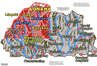
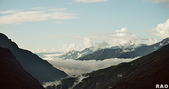
| Mochhu
Valley |
Gasa
Dzong |
Since
then several attempts have been made to reduce the risks of another glacial
lake outburst flood (GLOF), but geologists say the dangers are far from
over with changes in climate.
Since
the last inventory of glaciers and glacial lakes in Bhutan by the International
Centre for Integrated Mountain Development (ICIMOD) in 2001, 106 new
glaciers and 120 glacial lakes have formed in the mountains.
In
the past 15 years, 16 new glaciers and 82 glacial lakes had formed in the
headwaters of the Phochhu alone.
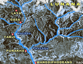 |
About
140 glaciers and four new glacial lakes had also formed in the headwaters
of the Mochhu, according to Glaciologist,
Karma Toeb, who presented the impact of climate change on glaciers and
glacial lakes in Bhutan Himalayas.
If
the present trend of climate change continues, there is a possibility of
another GLOF," the glaciologist said. "It is difficult to say when, but
the glaciers are melting at an alarming rate." According to geology experts,
the number of lakes posing dangers had increased from 24 to 25.
|
|
Karma
Toeb, who has visited Lunana eight times said that they have identified
nine potentially dangerous lakes in the Phochhu sub basin, seven in Mangde
chhu, five in Mochhu, three in Chamkhar, and one in Kuri chhu.
top
|
The
more impending dangers could come from fast retreating glaciers |
 |
Karma
Toeb said that the glacier retreat rate
in Himalaya of Bhutan was more rapid than the retreat rate in Nepal.
"Glaciers are retreating at a rate of 7.36 metres in a year," he said.
"There is an average of 10.7 percent shrinkage in glacier area and 3.28
percent increase in the lake area," he said.
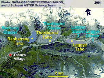
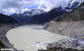
According
to geology officials, the Thorthormi ( Thorthormi) lake, 4,500 metres
above the sea level, has become critical and poses potential dangers. "The
debris covered glacial lake is expanding because the glaciers are melting,"
Karma Toeb said.
The
Thorthorm (Thorthormi) lake is located between the Luggye lakethat
flooded in 1994 and the Raphstreng lake. "The moraine dam between
Thorthormi and Raphstreng is not thick," the glaciologist said. "There is
ice core in the moraine and the moraine will become weak with the ice melting."
The Thorthormi
lakes left lateral moraine was eroded during the 1994 flood. "The Raphstreng
lake where artificial canalising had been carried out would not be able
to hold the water from the Thorthormi (Thorthormi) lake incase the
lake leaks because of the melting moraine," said Karma Toeb.
According
to geomorphologist Deo Raj Gurung, in a worst-case scenario, there could
be a chain reaction if one of the lakes burst in Lunana. "The volume
of water in the reservoir is about 18 million cubic metres, therefore it
is only wise to secure the downstream now," he said.
 |
| The
project, which would begin soon, is one of the adaptation methods to climate
change according to the director DGM, Dorji Wangda.
"A
base map on the hazards related to GLOF along the Puna tsangchhu can be
used as a tool by policy makers and planners in taking decisions, designing
and planning developmental activities along the river," he said. |
|
Presenting
the project to stakeholders, Deo Raj Gurung said that many important installations
and monuments lie along the Puna tsangchhu like the Punakha dzong, new
Wangduephodrang township, Basochhu project, Puna tsangchhu project
besides thousands of settlements.
 |
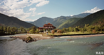 |
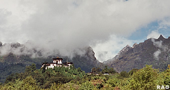
| Mochhu
Valley |
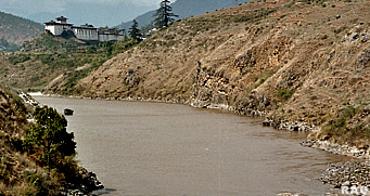
Punakha
Dzong: Confluence of Mo Chhu and Pho Chhu |
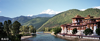 |
 |
| Punakha
Dzong |
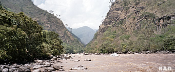
Punatsangchhu
Valley near Basochhu |
The
hazard zonnation map along the Puna tsangchhu would delineate areas along
the river into different zones of different degrees of hazards from GLOF
in future.
Meanwhile,
the Global Environment Fund had agreed to fund US$ 3.5 million for hazard
zonnation map in Chamkhar chhu in Bumthang, establishment of an early warning
system along the Punakha-Wangdue valley, and artificial lowering
of theThorthormi ( Thorthormi) lake.
| Contributed
by Ugyen Penjore, KUENSEL, Bhutan's National Newspaper, 2006 |
|
 |
 |
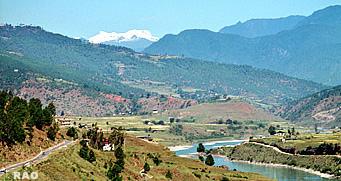
| Punatsangchhu
Valley near Wangdue Phodrang |
Wangdidzong |
|
More
Information |
|
 |
|
External
Links |
|