| Bhutan's
glaciers and glacial lakes |
 |
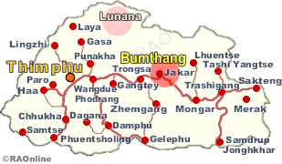
Bhutan Glaciers - Glacial Lakes |
|
|
Bhutan Glaciers - Glacial Lakes |
|
|
 |
|
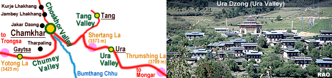
Bhumtang |
|
Glacial
Lake Outburst Floods (GLOF) |
 |
Bumthang step up GLOF mitigation works
In a few days, villagers from Chokhortoe in Bumthang would hike to higher mountains in Petsho to repair the Tsamba trail after floods upstream of Chamkharchhu flooded the valley in 2004.
"The flood was possibly caused by overflowing water from one of the potentially dangerous lakes at the source of Chamkharchhu burying the trial that year," Chokhortoe tshogpa, Sonam Jamtsho said.
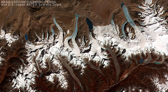
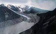
Chamkharchhu has three potentially dangerous glacial lakes at its source- Chubda, Thana and Ngangami tsho.
Lately, experts also found glaciers at the source of Chamkharchhu decreasing much faster, by 28 percent, than the 23 percent decrease in overall glacier area observed for Bhutan since 1980.
 |
International Center for Integrated Mountain Development ICIMOD warned potential risk of costly economic damages from GLOF on key development sectors like agriculture, hydropower and forests. An Asian Development Bank report has also cautioned of an overflow of potentially hazardous glacial lakes causing floods and landslides downstream destroying settlements, farms and hydropower sector as a result of climate change effects. |
Although it is not confirmed if GLOF caused the flooding at Tsamba in 2004, Sonam Jamtsho attribute the flood to overflowing water from one of the lakes at source of Chamkharchhu after incessant rainfall.
"Tsamba trial couldn’t be repaired for years from the lack of budget after floodwaters buried it," Sonam Jamtsho said.Herders, civil servants and Royal Bhutan Army (RBA) who used the trail hiked through different route.
This year the community would repair the trail with a financial support of Nu 0.14m from the gewog. "Our plan is to retrieve the trail by building a gabion wall to divert the water to its initial course," Sonam Jamtsho said.
Tsamba lam is critical for herders who spend 8-12 months in the mountains, civil servants trekking there for numerous reasons and RBA guarding the border.
"The trial is like a national highway for 48 herders, civil servants and RBA who has outpost in border areas," Sonam Jamtso said.
Chamkharchhu has also caused number of floods upstream in places such as Riphu, Ooukpala, Ngangla and Rungphu in the past.
"Six people died earlier during one of the cordyceps (cordyceps sinensis) collection seasons," Sonam Jamtsho said, adding no damages were however reported in downstream such as Chokhortoe, Jakar and Chamkhar.
But floods do pose risk to Dramphel and Sangsama villages, the army camp, school, Gross National Happiness center and Wangchuck Centennial National Park office in Chokhortoe, all located by the riverbank.
Similarly, Tangchu in Tang has also caused floods in 1999, 2009 and last year washing away farmlands of about eight households of Yumbang, Chhaling, Khangrub and Tangruth.
"Chhaling villagers lost 70 percent of their landholding to floods and still haven’t got any substitute land," Kizom tshogpa, Lekila said. Tang gewog clerk, Ugyen Lhendup said agricultural land is still vulnerable to floods in future because of its location.
The gewog however has constructed river protection wall through dredging last year in Tangruth. But similar works are pending in Chhaling and Yumbang.
Meanwhile, dzongkhag with Department of Hydro Met Services (DHMS) and Works and Human Settlement ministry is working on flood mitigation and protection works downstream especially along the riverbank in Chokhortoe, Jakar and Chamkhar.
So far Early Warning Systems were installed in Chokhortoe, Zhabgjaythang, Jakar, Chamkhar, Gongkhar and Gangrithang.
"The warning system were installed and villagers were educated on evacuation in Chokhortoe," thromde thueme, Karma Lekdhen said.
Dzongkhag engineer, Yeshey Dorji said over one kilometer of flood protection wall from Chamkharchhu bridge towards Wangdichholing was constructed recently. Another stretch of wall was also constructed in Gangrithang to protect property and farmlands.
Department of Civil Aviation has also carried river protection works securing entire stretch of domestic airport area in Bathbalathang.
"This year Nu 40 million has been allocated for construction of flood protection walls in Chakar and Wangdichholing areas," Yeshey Dorji said, adding construction of riverbank protection wall in Bathbalathang has already been tendered out.
| Source:
Contributed
by Tempa Wangdi, KUENSEL, Bhutan's National Newspaper 2016 |
 |
 |
 |
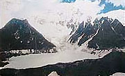 |
| Luggye
Lake |
Luggye
Glacier |
Raphstreng
Tsho |
top
| Information on Bhutan |
|
| Bhutan and Nepal
|
|
|
| Source: United Nations Disaster Management Team, 2005 |
|
Links
|
|
 |
|
External
Links |
 |
 |
 |
 |
 |
| GRID-Arendal
News |
NASA's
Global Change Master Directory |
United
Nations Environment Programme |
World
Glacier Monitoring Service |
International
Centre for Integrated Mountain Development |
|
 |
 |
 |
|
|