|
 |
Banepa |
is
located 26 km east of Kathmandu on the Arniko Highway, the modern version
of the ancient trade route to Tibet. Also known as Bhonta this quaint Newar
town has a glorious history as a flourishing trading post and important
political centre. Banepa (altitude 1,461 m) offers artistic temples, monasteries,
rest houses and a colourful culture marked by vibrant festivals. The most
important shrine here is that of the goddess Chandeswari who has both Hindu
and Buddhist features.
 |
Bhaktapur |
 |
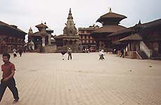
Bhaktapur
lies some 10 km east of Kathmandu. Built on a plateau at 1400 m on the
northern bank of the Hanumante river. Bhaktapur ist the samllest of the
three cities of the Kathmandu valley. In its Durbar Sqare, Taumadhi Square
and Tattatrtaya Square the city has the valley's finest panoply of architeture.
The Nyatali Mandir is the tallest pagoda temple in Nepal.
|
 |
Baglung |
is
situated 60 km west of Pokhara at an altitude of 1,120 m. It is a trading
town of quaint streets and traditional buildings where merchants from the
Terai plains in the south and the hills in the north come together to barter.
Splendid views of the Dhaulagiri range can be had from here.
 |
Bandipur |
is
a hilltop town situated midway on the Kathmandu -Pokhara highway at an
altitude of 1,005 m overlooking the Marshyangdi river valley. In the early
1800s, the ordinary mountain village was transformed into a vibrant commercial
centre on the Tibet India trade route after Newar traders from Bhaktapur
moved here. Bandipur offers mountain views, artistic houses and pagoda
temples. It has the largest cavern in the country, the Siddha Gupha, which
is full of stalactites and stalagmites.
 |
Budhanilikantha |
 |
Budhanilikantha
is situated some 9 km north of Kathmandu's center. Revered as an emination
of Avalokikiteshwara by Newar Buddhists, and by Huduists as Narayana, an
incarnation of Lord Vishnu lying on a bed of naga spirits or snakes on
the foot of Shivapuri Hills.
The
stone sculpture was fashioned by King Vishnugupta in the 7th century. |
 |
Charikot |
is
located at 2000 m to the north-east of Kathmandu can be reached in 4-5
hours by car. The Arniko Highway, the road to Tibet, descends to the valley
of the Sun Koshi, offering a scenic view of the whole Himalayan range.
Turning east by crossing the Sun Koshi river the road climbs up to 2,600
m providing spectacular views of the mountains of the East and West before
gently descending to Charikot, situated on a ledge, 1000 above the Tama
Koshi valley.
 |
 |
 |
Charikot
Panorama Resort HOME |
|
|
 |
|


